The first world atlas confused Cuba with Cyprus
The Utrecht University Library tells the story of a 1606 edition of Gerard Mercator’s Atlas sive Cosmographicae Meditationes… that was, um, less than perfectly prepared:
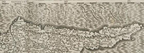
In the Utrecht copy shown here the map of Cyprus has been included twice. One time at the right place at the description of the island, and one time incorrectly at the description of Cuba! To err is human, also when making an atlas. In this case the printer used the wrong copperplate when printing the map on the overleaf of the text pages which had been made earlier via another technique, namely letterpress printing. Or a mistake must have been made during the collection of the map prints needed, if the texts had to be printed afterwards. The latter way of working was quite unusual however. As far as we know, only the Utrecht copy contains the mistake of the switched Cuba-Cyprus map. But that is not to say that incorrect placements and switched maps did not occur in other old atlases. In a copy of the same edition of Mercator’s atlas, housed in the University Library of Odense, the continent map of Africa has been switched with the one of America.
Mercator (of projection fame) had died in 1594. His Atlas the first “book work with maps (1585-1595) which was given the name Atlas,” and popularized the term, but Abraham Ortelius’s “Theatrum Orbis Terrarum” in 1570 was probably the first book we’d recognize as a modern atlas. Mercator wanted to bring scholarly, scientific precision to the work that Ortelius and a generation of mostly-Dutch commercial mapmakers had pioneered.
But the atlas was unfinished, with only 79 of a planned 120 published, and another 34 complete. There were no maps of continents outside Europe, or even of Spain and Portugal. Mercator’s son Gerard Jr. sold his father’s copperplates, and they eventually ended up in the hands of cartographer Jodocus Hondius. Hondius assembled and augmented Mercator’s maps, adding four maps of Africa, eleven of Asia, and five of the Americas, plus correcting that pesky Iberian peninsula problem. He published them as a series, they became hugely popular, and Mercator’s reputation was restored.
But there is that one weird Utrecht edition with Cyprus standing in for Cuba and Africa for America. Still, in fairness to whoever switched the bookplates: they had probably never seen images of any of these places before.
Stay Connected